Groundwater is not available everywhere in the required quantity and desired quality. Various studies like geological, hydrological, aerial photo studies, remote sensing and geophysical methods are applied to understand the behavior of Groundwater in Basalts. One such study is Geophysics. Geophysics is the study of physical properties of earth. The physical properties are revealed in understanding the subsurface geology with feasible structures for groundwater availability. This information about understanding subsurface geology can be achieved by using different geophysical methods. The obtained data is interpreted in terms of local geology to identify feasible sites for groundwater development. The role of Geophysics in groundwater exploration is vital to understand sub-surface conditions accurately and adequately. Under this wing the following activities have been carried out.
Site selection for bore well, tube well, dug well under various schemes like RWS, PWS, LGW, Jalswarajya, Jal Jeevan Mission, Atal Bhujal Yojana, NHP etc.
Feasibility for source strengthening structures like FSC, BBT, Stream blasting under Unconventional Measures. Post project analysis could also be carried out, to ascertain the effectiveness of the measures undertaken.
Special studies under Research and Development activities like confirmation of lineaments, seepage losses studies, source strengthening measures etc.
The surveys are extended to demarcate aquifer boundaries under AQMP and other similar projects.
With the increase in demand, surveys are carried out to advice the feasibility of groundwater for cultivators, Institutions, Industries etc. with a nominal fee of Rs. 5000/- deposited in treasury.
In Jalswarajya Project geophysical survey was carried out in delineating the aquifer.
The following Geophysical methods are predominately being used in G.S.D.A.
i)Electrical Resistivity Method
ii)Very Low Frequency Electro-magnetic Method
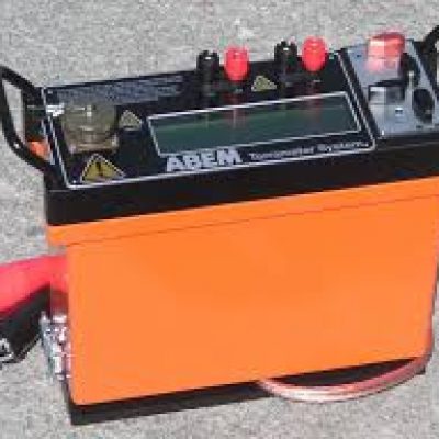
Resistivity meter
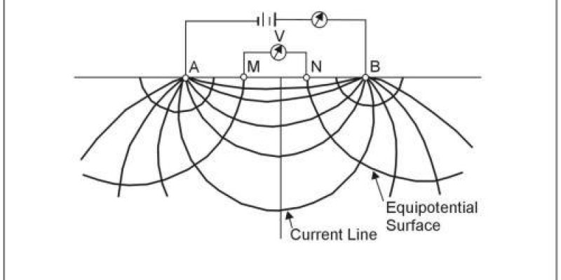
This instrument is used to find out the information about the ground layers with high and low electrical resistivity. For the survey, electrical resistance is measured by passing electric current underground through four electrodes. Through this method, information about the electrical resistance of different levels is collected and according to that, the place for bore well, dug well, tube well is determined. This technique is used to obtain information about water quality in saline water catchment areas.
Electrical Resistivity Profiling
Vertical Electrical Sounding Curve
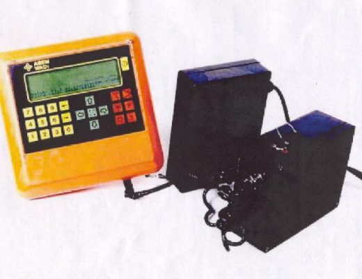
VLF Wadi
With this device, electromagnetic waves are sent underground to survey the network of cracks that hold water beneath the surface. Also, this instrument is useful for extracting information about underground layers in hard rock areas, urban areas with limited area availability where surveying with resistivity meter is impossible.
VLF EM Current Density Cross Section & Profile
Procedure for taking technical guidance from GSDA by the Farmers/ Individuals/ Institutions for drinking water and Irrigation wells and bore wells –
For the benefit of the public, the geophysical survey fee of rupees five thousand (Rs. 5000/-) per site is being charged. Technical guidance for digging of wells for irrigation and bore wells for drinking water is being given.
Whoever wants to conduct geophysical survey in his premises he has to submit 7/12 document with the application to the concerned District Senior Geologist office. The concerned Geophysicist from the respective regional office will be conducting the survey.
Consultio comes with a beautiful collection of modern, easily importable, and highly customizable demo layouts. Any of which can be installed via one click.